 |
| Picture Credit: cafod.org.uk |
By Geoffrey Kamadi
April 3, 2012
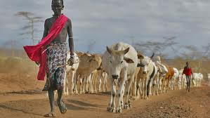
Satellite technology is coming to the aid of pastoralists in drought-stricken Kenya, with the expansion of a water monitoring system that aims to reduce livestock loss.
The Livestock Early Warning System combines information uploaded by villagers with satellite data to create a virtually real-time map of forage and water conditions.
A successful pilot project in Turkana district in northwest Kenya is being considered for extension across the country.
“The whole idea is to automate the process of providing information on water conditions in the pastoral areas in a reliable, timely and consistent manner,” said Laban MacOpiyo, the scientist in charge of the project at the University of Nairobi.
The system uses technology developed by Texas A&M University in the United States and has been used in several states there, as well as in Mali and Mongolia, said MacOpiyo.
The current programme began in southern Ethiopia and northeastern Kenya. MacOpiyo said the UN Food and Agriculture Organization (FAO) provided $30,000 for its expansion in October 2011 into Turkana District, where an additional 12 monitoring sites were established by the University of Nairobi and Texas A&M.
SATELLITE DATA AND MOBILE PHONES
The project uses Geographic Information System (GIS) mapping with open-source data. Villagers have been trained to use mobile phones to record information about water levels and the number of households and specific livestock – camels, donkeys, cattle, sheep or goats – using particular waterholes.
These data are combined with satellite images generated by the US National Aeronautics and Space Administration (NASA) to identify water sources, which are then visited by monitoring staff to ensure that water is present.
“We want to look at the conditions, the water quality, and distance trekked by livestock to a waterhole, as well as the forage conditions in the region,” said Joseph Matere, an FAO official in Nairobi, Kenya’s capital.
The data from locals on the ground and from NASA are fed into a computer that models the topography of the region along with hydrological characteristics such as infiltration, evapo-transpiration and surface run-off, explained MacOpyio.
The computer generates colour-coded images of the land. Green indicates normal vegetation cover, yellow suggests that the vegetation is getting poor, while brown means that it is scarce.
“Yellow areas … imply that long-term vegetation conditions are 20 to 40 percent below normal, which points toward drought conditions,” said Matere.
The aim is to come up with “a very reliable early warning system” and to give pastoralists faced with water shortages ideas on how to cope with drought conditions.
TAKING ACTION
These might include de-silting and repairing strategic water sources, vaccinating and de-worming livestock to make them better able to stand adverse conditions, and establishing fodder production units. In more severe situations, experts might advise pastoral communities to use reserve grazing land if available or to sell their livestock well before the water situation becomes critical.
Matere said the FAO wants to encourage rehabilitation of degraded rangeland by fencing off areas in an effort to eventually improve grass availability.
In addition, it hopes to establish feed banks along migration routes so that livestock do not die enroute.
Computer models could also reproduce historical data, showing water conditions in years past. This could help scientists forecast conditions more accurately over periods ranging from three months to five years.
“This water monitoring system is very useful because it gives specific information on water and drought conditions of a specific area,” said Elizabeth Lokolio, a livestock officer with a Turkana pastoralist organization. She was trained as one of the project’s drought monitors.
Lokolio said that that the new method of communicating about water conditions is far superior to traditional practices, which relied on village elders to report information.
As part of the program, forecasts and advice are communicated to Turkana pastoralist communities via the Internet – accessed in part on mobile phones - but MacOpiyo said that scientists hope to work with the National Drought Monitoring Authority to disseminate their forecasts through community radio, text messaging and community meetings as well.
The pilot project in Turkana ended in February of this year, and MacOpiyo and his colleagues are now seeking FAO funding to support its continuation and expansion into other arid and semi-arid parts of the country.